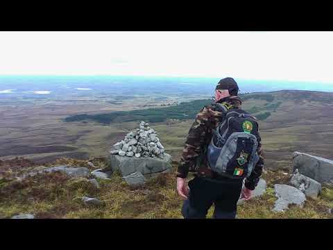
Benbeg

Benbeg, also called Cuilcagh South East Top or Binn Bheag in Irish, is
the small peak walkers cross on the way to the Stairway to Heaven
boardwalk from County Cavan. At about 540 metres, or 1,761 feet, it
is the highest point of the ridge on the Cavan side of the border,
and in fact it was the original way onto Stairway to Heaven before
the boardwalk was built.

The walk begins at a small picnic area at Bellavally Gap, part way
up the hill. From the car park the route enters forest and climbs
past a satellite communications mast, crosses a stile and a fence,
then opens onto boggy, broken ground. The summit is reached in
roughly half an hour from the start, and the rest of the ridge runs
across to Cuilcagh itself on a clear but unwaymarked path that is
muddy in places. Boots, gaiters and waterproofs are essential, dogs
are not allowed on the route even on a lead, and the top can be
cold and misty even when it is sunny at the start.

About Benbeg [Cuilcagh South East Top]. [Binn Bheag]

Grid reference H119254
Height in metres 538 metres
Height in feet 1765 feet
Latitude 54.177486
Longitude -7.818507
Country Ireland
County County Cavan
Weather View Weather

Walk videos

Route notes, timings, and viewpoints from walking videos.

Cuilcagh via Ben Beg

Walk the Walks with Paul

7 notesfrom YouTube

This is a Cuilcagh walk that goes via Ben Beg, in County Cavan. Just beyond Ben Beg is Stairway to Heaven on the Fermanagh side, so the two are close neighbours along the ridge.

Show 7 notes
  • Route

    This is a Cuilcagh walk that goes via Ben Beg, in County Cavan. Just beyond Ben Beg is Stairway to Heaven on the Fermanagh side, so the two are close neighbours along the ridge.

    and just over Ben bag then is Stairway to Heaven from the fir Mana side
    Watch at 0:14
  • Route

    Walkers give roughly half an hour from the start to reach the top of Ben Beg before beginning the Cuilcagh section of the walk.

    probably half an hour walk up to the top
    Watch at 0:28
  • Observation

    The climb up Ben Beg is steep, the final section from three-quarters of the way up taking about 20 minutes. Above it the terrain is up and down and boggy in places, with walkers mostly finding their own way.

    some of the terrain up here it's up and down really and a little bit buggy at times
    Watch at 1:40
  • Safety

    Walkers stress waterproof boots, waterproof socks and rain gear because of the boggy ground.

    don't forget waterproof boots waterproof socks rain gear
    Watch at 2:18
  • Observation

    From the top of Ben Beg, Stairway to Heaven is visible straight across the same ridge, roughly 200 yards away.

    go look straight across there that's actually Stairway to Heaven
    Watch at 4:26
  • Observation

    The top of Ben Beg is exposed and freezing, and mist can roll in even when the sun is out elsewhere.

    it's absolutely freezing up there
    Watch at 4:59
  • Safety

    The closing advice repeats the kit list: waterproofs, boots, waterproof socks, gaiters, rain gear, 1-2 litres of water and sandwiches.

    Gators is a must and then your rain gear and don't forget your L 2 lers of water
    Watch at 8:49

Hiking Vlog: Bunnacunneen Mountain

Irish silver stack

1 notefrom YouTube

From the top of Bunnacunneen Mountain, Ben Beg is the next peak along the ridge. A group planning to climb both stopped when the descent gap between them proved far too steep.

Show 1 note
  • Route

    From the top of Bunnacunneen Mountain, Ben Beg is the next peak along the ridge. A group planning to climb both stopped when the descent gap between them proved far too steep.

    we're going to see ben begg beyond that we're assuming we're going to be able to do two of them
    Watch at 0:34

Hiking to Cuilcagh & Benbeg Mountains from Bellavally Gap, Co. Cavan, Ireland, Nov 21 2023

Ashley and Andrea's Adventures

8 notesfrom YouTube

The walk starts at a picnic area at Bellavally Gap in County Cavan, about a 40-minute drive away. A map board at the picnic site shows the local paths, and the car park sits part way up the hill so some of the elevation is already done.

Show 8 notes
  • Route

    The walk starts at a picnic area at Bellavally Gap in County Cavan, about a 40-minute drive away. A map board at the picnic site shows the local paths, and the car park sits part way up the hill so some of the elevation is already done.

    I've driven for 40 minutes to a place called I think it's Bella Valley Gap
    Watch at 0:48
  • Route

    The route leaves the forest at a satellite communications mast, crosses a stile and follows a fence past a bog conservation in progress sign before the open ridge climb.

    I've reached this satellite Communications Mast and uh this is the end of the forest
    Watch at 5:14
  • Observation

    At the summit of Ben Beg the height is given as 1761 ft, described as the highest point of the ridge.

    Watch at 8:20
  • Route

    A clear, well-trodden path follows the ridge line from the Ben Beg area on the way towards Cuilcagh. It is muddy and boggy in places but would be a good summer route.

    it's a very clear path it's a we bit muddy but in summer this would be a really good path
    Watch at 8:50
  • Route

    No other safe descent was found off the summit ridge, so the walker returned by the same route.

    just going to head back the same way I came
    Watch at 17:11
  • Observation

    The walk is praised for its views, described as phenomenal throughout the outing.

    the views are phenomenal
    Watch at 18:34
  • Route

    There is a good path the whole way to the top of Cuilcagh, though it is not waymarked.

    there is a good path the whole way to the top
    Watch at 21:07
  • Summary

    The Ben Beg to Cuilcagh route is judged a far better hiking challenge than the boardwalk, which makes the going easy rather than a genuine hike.

    this is a far better walk than boardwalk in terms of hiking and a hiking challenge
    Watch at 21:12

Stairway to heaven via Ben Beg

Walk the Walks with Paul

7 notesfrom YouTube

One walker following the original way to Stairway to Heaven over Ben Beg describes the hill as roughly 1800 ft (about 550 m) high.

Show 7 notes
  • Observation

    One walker following the original way to Stairway to Heaven over Ben Beg describes the hill as roughly 1800 ft (about 550 m) high.

    roughly about 1800 feet high
    Watch at 0:52
  • Route

    One outing on the original Stairway to Heaven route totalled about 25,000 steps and took roughly six hours, with the walk itself about 11 km.

    it was 25000 steps and we've done it in roughly six hours
    Watch at 8:55
  • Route

    Ben Beg is reached fairly quickly from the start, with walkers able to be on the top within about half an hour.

    within a half an hour or so you'll be on the top
    Watch at 9:16
  • Safety

    For this walk a good pair of boots, gaiters and around 1.5 litres of water are called essential.

    for this walk you will definitely need good pair of boots and Gators and definitely around a liter and a half of water
    Watch at 9:27
  • Safety

    The track is fairly good but can be dangerous at times because it skirts the edge of the mountain; it becomes boggy in places once up on top.

    dangerous at times because you're skirting around the edge of the mountain
    Watch at 9:36
  • Other

    Dogs are not currently allowed on the route, not even on a lead.

    there's no dogs allowed not even on a leash
    Watch at 9:54
  • Summary

    The Ben Beg route is described as the original Stairway to Heaven, the actual route taken before the boardwalk was built. An experienced group met on the hill said the tourist boardwalk from the Fermanagh side only covers about three-quarters of the walk, so you have not truly done Stairway to Heaven until you have done the Ben Beg approach.

    if you think that you have done Stairway to Heaven you actually haven't done it until you've done this walk
    Watch at 10:16