Pendle Hill

Trig Point · TP10114

About Pendle Hill

ReferenceTP10114
Grid referenceSD804414
Height in metres557 metres
Height in feet1828 feet
Latitude53.86855517
Longitude-2.298559495
CountryEngland
Pillar typePillar
ConditionDestroyed
Historic useSecondary
Current useNone
Mountain Pendle Hill
Trigpointing UKView record

Best time to visit Pendle Hill

Best months to visit: May, Jun, Aug

These months tend to be warmer and drier than the rest of the year.

Hottest months: Jun, Jul, Aug

Coldest months: Jan, Feb, Mar

Rainiest months: Jan, Oct, Dec

JanFebMarAprMayJunJulAugSepOctNovDec
Day temperature3 °C5 °C7 °C10 °C13 °C15 °C16 °C16 °C14 °C11 °C6 °C5 °C
Night temperature-2 °C0 °C0 °C1 °C5 °C8 °C9 °C9 °C7 °C5 °C2 °C0 °C
Rain118 mm115 mm91 mm70 mm85 mm95 mm97 mm81 mm105 mm128 mm110 mm139 mm

Based on Pendle Hill, 0.0 km away. Historical seasonal averages. Weather data by Open-Meteo.

Walk videos

Route notes, timings, and viewpoints from walking videos.

Pendle Hill Walk from Barley | Full Circular Route & Steep Summit Climb

MCM Outdoors

7 notesfrom YouTube

Pendle Hill is a popular Lancashire Pennines walk, most commonly started from Barley village. The shortest route takes the steep stone steps (the "rake") up to the trig-point summit; longer loops go via Ogden Clough or the Nick of Pendle. Walkers finish at the Pendle Inn in Barley.

Show 7 notes
  • Summary

    Pendle Hill is a popular Lancashire Pennines walk, most commonly started from Barley village. The shortest route takes the steep stone steps (the "rake") up to the trig-point summit; longer loops go via Ogden Clough or the Nick of Pendle. Walkers finish at the Pendle Inn in Barley.

    Right, so we've just arrived at Pendle Hill Barley car park and we're going to go and do the summit of Pendle Hill.
    Watch on YouTube
  • Observation

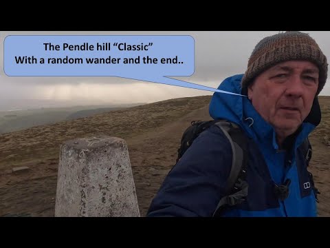
    The trig point sits at the summit of Pendle Hill. From the top of the stone steps the walk to the trig is roughly level.

    Pendle Hill trig point. Here we go. The summit of Pendle Hill.
    Watch at 10:05
  • Route

    From the summit, a path leads down Ogden Clough on the east side back to the Ogden reservoirs, then on to Barley. This is the original Pendle Way route.

    So, there's a path that goes that way to Ogden Clough. Which is the original route that I had planned.
    Watch at 11:03
  • Observation

    A very small cairn sits near the trig point. One walker described it as "the world's smallest cairn."

    It's the world's smallest cairn. I've got to tap it.
    Watch at 11:23
  • Safety

    The descent from the summit towards Ogden Clough is steep and the ground is uneven. Walkers should take care, especially in wet conditions.

    It's quite steep coming down there, don't it? Not very decent ground, so you do have to be a bit careful.
    Watch at 12:40
  • Other

    Pendle Hill is strongly associated with the Pendle witches of 1612. A board on the route quotes a contemporary description: "Female cunning manless old daughter of such an evil faith. And the mark of Pendle. A crone."

    Female cunning manless old daughter of such an evil faith. And the mark of Penble. A crone.
    Watch at 14:35
  • Other

    The Pendle Inn in Barley is the popular post-walk destination. Walkers finish there for a pint, and the pub is mentioned in route guides online.

    Pendle Inn. Yep, so we're going to the Pendle Inn for a pint now.
    Watch at 21:24

Pendle Hill Walk from the Nick of Pendle - The Full Walk in 4K

Walks4all

2 notesfrom YouTube

An alternative start point is the layby at the Nick of Pendle, just outside Sabden in the Ribble Valley. From here the route climbs via a less-direct line up Pendleton Moor and onto the summit.

Show 2 notes
  • Route

    An alternative start point is the layby at the Nick of Pendle, just outside Sabden in the Ribble Valley. From here the route climbs via a less-direct line up Pendleton Moor and onto the summit.

    today's walk is Pendle Hill from the nick of Pendle just outside sabon a village in the rubble Valley in Lancashire
    Watch on YouTube
  • Route

    On the standard descent from the summit, the path passes through a wall gap then goes past the weather shelter and Scout Carn before crossing Pendle Moor.

    we then pass through the wall to pass by the weather shelter and then onto and by the the Scout can
    Watch at 37:20

Hike to Pendle hill, Lancashire, Bowland Fells

Lancashire Lad

3 notesfrom YouTube

The main start point is Barley car park, a paid car park in the village. The fee was described as "a couple of pounds for 3 hours." Free roadside parking is also available near the car park.

Show 3 notes
  • Route

    The main start point is Barley car park, a paid car park in the village. The fee was described as "a couple of pounds for 3 hours." Free roadside parking is also available near the car park.

    parking here but you do have to pay for it I think it's uh it's not a lot of money couple of pounds for 3 hours
    Watch at 0:50
  • Observation

    Pendle Hill summit reaches 557 metres (1,827 feet). One walker recorded 563 m of elevation on the GPS reaching the trig, but the trig is at 557 m.

    pel Hill Sumit 500 and 57 M
    Watch at 9:48
  • Observation

    From the summit you can pick out Ingleborough and Pen-y-ghent (two of the Yorkshire Three Peaks) to the east. To the south lie the Bowland Fells: Beacon Fell, Parlick Fell, Fairsnape Fell, and Totridge.

    you can see some of the ORS are three Peaks got inle here fish and over here you got Penny Gant the big Noble just to the side of it pH in fell
    Watch at 9:50

The Pendle hill classic, Bowland fells, Lancashire

Lancashire Lad

2 notesfrom YouTube

The walk passes through Barley village after leaving the car park. Several videos show the cabin café in Barley used as a post-walk stop.

Show 2 notes
  • Route

    The walk passes through Barley village after leaving the car park. Several videos show the cabin café in Barley used as a post-walk stop.

    so I'm just making my way over to the village now walk through the village
    Watch at 1:23
  • Route

    The most direct ascent from Barley uses a stone-stepped path known as the "rake" or the "steps of death." The climb takes about 20 minutes but feels longer. There is an alternative path from the bottom of the steps with the same overall climb.

    going to continue down the path a little way and cross that bridge and head off up that lane
    Watch at 5:20

Gallery

Map

Classifications